
A303 Stonehenge Improvement
Explanation of the Scheme and Non-Technical Summary of the Environmental Statement
June 2003
This is a scan we made of the Non-Technical Summary before the Highways Agency made it available on their own website. We would dispute many of the claims that the Highways Agency makes here.
For a copy of the printed version of this leaflet (which contains numerous maps and photos), please contact:
The Stonehenge Project
Highways Agency
Zone 2/05 - K
Temple Quay House
2 The Square
Temple Quay
BRISTOL BS1 6HA
Or read their official online version of the NTS here.
 Introduction
Removal of busy roads and other 20th century clutter from sight of Stonehenge
has long been a Government objective. The A303 Stonehenge Improvement is
being promoted by the Highways Agency as an exceptional environmental scheme
in recognition of its unique context. The scheme includes a tunnel past
Stonehenge to put trunk road traffic underground and out of sight. The
12.4 km long road scheme including the tunnel is an essential first step
in securing the aims and objectives of the Stonehenge World Heritage Site
Management Plan (English Heritage 2000).
This leaflet describes the Published Scheme proposals and summarises the Environmental Statement (ES) which has been published in accordance with Directive 97/11/EEC as applied by Section 105A of the Highways Act 1980 as amended. The ES supports the draft Orders which have been published for this scheme.
Why scheme is needed
The A303 Trunk Road links London with the South West; it is a key route for long distance commercial and holiday traffic. Much of the route has already been improved to dual carriageway standard and further improvements are planned to upgrade many of the remaining slow, narrow and dangerous sections. The A303 through the World Heritage Site (WHS) and past Stonehenge itself is the first single carriageway section that drivers encounter after leaving London.The monument suffers from A303 traffic, only 150 metres away, and even worse intrusion from the A344, which virtually touches it. The proposed tunnel would hide the roads and traffic from view at Stonehenge. It would allow the heritage landscape to be restored to its prehistoric setting.
In the summer, principally at weekends, traffic builds up along this section of the A303 and is often at a standstill. Residents of Winterbourne Stoke suffer from the A303 running through the village. On average, between 22,000 and 33,000 vehicles, many of which are large lorries, travel along the road each day. This is more than a single carriageway road can cope with satisfactorily, so queues are a regular and predictable sight. Congestion is inconvenient, but traffic accidents are the other inevitable outcome of roads under stress. There are accident blackspots on the approaches to WinterbOLirne Stoke and at the junction with the A344 at Stonehenge Bottom. A bypass for Winterbourne Stoke would secure substantial improvements for the majority of residents and the scheme generally would reduce accidents and alleviate the present causes of congestion.
The Published Scheme
The Scheme (shown in the main figure opposite) would run eastwards from the end of the existing dual carriageway at Berwick Down. The route would first pass south of the existing road before swinging to the north east to bypass Winterbourne Stoke. At this point a junction would be provided to permit access to and from the village from the west. Just to the east of the junction, where the route would pass south of Parsonage Down, a 'green bridge' would be provided over the now road to allow the safe passage of wildlife.From here the route would descend into the valley of the River Till where it would pass under the realigned B3083 Shrewton Road. The route would then cross the flood plain of the River Till on a viaduct 200 metres long. The ground either side of the viaduct crossing would be shaped to screen the new road as much as possible from Winterbourne Stoke. The route would then climb out of the river valley, passing under a new bridleway bridge before crossing the line of the existing road on the approach to Longbarrow Crossroads. There would be a new 'dumb-bell' (twin-roundabout) junction here, with the route passing in cutting under the A360. A further roundabout just to the west on the old A303 would provide access to Winterbourne Stoke from the east.
From Longbarrow Crossroads the route would run in cutting parallel to and on the south side of the existing road for approxirtiately 1.5km before heading into tunnel. The tunnel, which would be formed of two bores, would run to the south of the existing road in a gentle curve for a distance of 2.1 km before emerging east of King Barrow Ridge. Both tunnel portals would be out of sight of Stonehenge. The tunnel would not break ground over this length except in Stonehenge Bottom where some construction would be carried out from ground level. After completion of the works, Stonehenge Bottom would be reinstated and the existing A303 causeway restored to historic turnpike levels.
Between Longbarrow Crossroads and King Barrow Ridge, a new 'green byway would be created, generally following the line of the existing A303. The byway would provide a route across this part of the WHS for non- motorised users who would be prohibited from using the tunnel. The byway would link with existing Rights of Way in the area.
From King Barrow Ridge, the route would descend towards Amesbury and the A345 at Countess Roundabout, keeping generally to the line and level of the existing dual carriageway. The A303 would be carried over the roundabout on embankment and two new bridges, the existing layout being retained underneath with the addition of traffic signals. The route would then re-join the existing A303 before crossing the River Avon.
Measures to secure Environmental Benefits
Major environmental benefits would flow from restoring the setting to Stonehenge and removing traffic from the village of Winterbourne Stoke; the Published Scheme with its 2.1 km tunnel and bypass of the village would secure these. Detailed attention has been paid to the following:- maximising the benefits to the setting of the Stones within the heart of the WHS and limiting the impact on archaeological and historic sites elsewhere
- balancing landtake within the WHS with the effect on the heritage landscape
- minimising disturbance to wildlife, protecting and enhancing existing habitats and species, and creating new habitats where appropriate
- minimising effects on the ecological systems of the Rivers Till and Avon
- maintaining water quality in the chalk aquifer and in the river systems, both during and after construction
- reducing noise levels for Winterbourne Stoke residents and for visitors to Stonehenge
- removing existing visual intrusion and minimising new intrusion
- maintaining and improving provisions for pedestrians, equestrians and cyclists
- designing high quality, aesthetically pleasing structures
- blending the route into the landscape and landform
- recycling and reusing material, and avoiding the creation and disposal of waste.
Cultural Heritage
The Stonehenge World Heritage Site (WHS) is a landscape of international importance. Stonehenge is Britain's best known prehistoric monument, but is spoilt by 20th century clutter. It is less well known that the area surrounding the Stones contains a uniquely rich concentration of prehistoric sites. The Published Scheme, with its 2.1 km tunnel, would enable Stonehenge and its nearby associated monuments to be reunited, allowing the mystery of this remarkable landscape to be better appreciated. The setting of Stonehenge within the WHS would be transformed and access to the Stones and large parts of the WHS would be a more rewarding experience.Great efforts have been made to find a route trial has no direct impact on any scheduled monument, a difficult proposition when working in one of the richest archaeological landscapes in the country. The Published Scheme succeeds in that aim. Archaeological remains have been explored by modern techniques that do not break the ground surface and by selective digging. All this work has been done in close consultation with English Heritage. An exciting discovery led to a change in route alignment at the western end to avoid a previously unexplored Iron Age settlement near Winterbourne Stoke. A comprehensive programme of further investigations, building upon what has already been done, would be carried out before and during construction, which would add significantly to knowledge about the Stonehenge landscape.
Winterbourne Stoke Conservation Area, would benefit considerably front the removal of A303 traffic. The effect would be more limited on the Amesbury Conservation Area, nearby listed buildings and the adjacent Registered Historic Parkland.
No route through the WHS, however carefully selected, can avoid some adverse impact. The Scheme would have an indirect effect on the setting of some monuments remote from the Stones, and there is always the potential to disturb as yet undiscovered archaeology, no matter how intensive the prior investigations. Neverthoess, the major heritage benefits secured by the Published Scheme would substantially outweigh the known adverse effects that would occur at a limited number of sites. Overall the Scheme would have a highly positive effect upon the heritage resource.
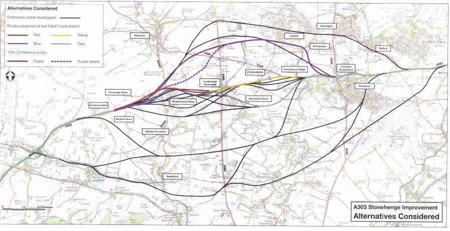
Alternatives considered
Studies and consultations into alternatives for the A303 Trunk Road between Amesbury and Berwick Down have been underway since 1991 (see figure above). The main stages have been:1991-1993 - Initial route identification considered over 50 possible routes, ranging from north of Larkhill to south of Stapleford.
1993 - Public Consultation on two routes for the Stonehenge section (Yellow and Grey) and two routes for Winterbourne Stoke Bypass (Red and Blue). This consultation was inconclusive for the Stonehenge section and showed a general preference for the Red Route for the Winterbourne Stoke Bypass.
1994-1995 - Further route identification considered tunnel options and northern routes (Purple and Purple variant).
1995 - Planning Conference looked at all options. The conference supported in principle a long tunnel under the Stonehenge site (whilst recognising the potential funding difficulties) and strongly supported the need for the Winterbourne Stoke Bypass.
1998 - New "exceptional environmental scheme" announced by Government for a bypass of Winterbourne Stoke and dualling on line of the existing road with a 2 km cut and cover tunnel for the section past Stonehenge.
1999 - Public Consultation on the 1998 scheme, jointly by the Highways Agency and English Heritage. Following consultation, the Government announced the Preferred Route for the Stonehenge Improvement in June 1999.
2001-2002 - Review of tunnel options of different lengths (ranging from 2.0 km to 4.5 km) and methods of construction (cut and cover, bored and combinations of these). The decision, taken jointly, by the Secretaries of State for Transport and for Culture, Media and Sport, announced on 10th December 2002, was for a 2.1 km bored tunnel.
At each stage detailed environmental and economic assessments were undertaken, and decisions made were informed by the public consultations in 1993, 1995 and 1999.
Landscape
The landscape of the study area is dominated by rolling chalk downiand of high scenic quality, all of which is designated a Special Landscape Area by Wiltshire County Council. This is an open landscape with long distance views across successive ridgelines, interrupted by blocks of woodland, which form dramatic features. As well as the dry valleys typical of the chalk downiand, there are more enclosed fertile and well vegetated valleys along the Rivers Till and Avon, containing attractive settlements and scattered dwellings.For visitors to Stonehenge, the Scheme would offer significant benefits to the internationally important landscape setting to the Stones. It would improve the views across rolling chalk downland by removing from sight the A303 and A344 traffic. For residents of Winterbourne Stoke the Scheme would substantially reduce intrusion by removing most of the traffic from the village.
Not all the landscape effects would be positive; the wider road corridor west of Longbarrow Crossroads junction would encroach into open countryside. To help disguise this, a new landform would be created alongside the route, blending it into the surrounding contours from many viewpoints and reducing noise and visual intrusion. The proposed River Till viaduct, although as low to the ground as possible, would still be visible from some properties on the north side of Winterbourne Stoke. Either side of the tunnel, the portals and approach cuttings would form a new locally visible feature within the WHS, but the visual effect would be minimised by keeping highway boundary fencing below existing ground level and allowing natural vegetation to establish on slopes over time. At Countess Roundabout, elevating the A303 would affect the setting of listed buildings at Countess Farm, but this could be reduced by planting to screen views from the buildings.
On balance the Published Scheme would have overall benefits in both landscape and visual terms.
Nature conservation and biodiversity
Near the western end of the Scheme and just to the north of the route, lies the extensive, chalk grassland Parsonage Down National Nature Reserve (NNR), part of the Salisbury Plain candidate Special Area of Conservation (cSAC) and containing a Site of Special Scientific Interest (SSSI). Internationally important ecological resources are also concentrated along the River Till SSSI and River Avon SSSI, with both SSSIs forming part of the River Avon cSAC.Extensive surveys of all the ecological resources, both within and outside the above sites, have been undertaken in consultation with English Nature and the Environment Agency. These surveys have fully informed the design of the Scheme. The route would be kept in a cutting far enough away from Parsonage Down to avoid any significant impact on the SSSI/cSAC. Careful route alignment over the River Till and the use of a long viaduct would minimise the risks of any harmful effects. The Scheme's drainage design would reduce the risk of pollution in both the Till and Avon, helping to ensure that the river habitats can improve over time to support an even greater variety and richness of species within the cSAC. Although the river habitats immediately beneath the proposed River Till Viaduct would be in shade, the overall integrity and potential of the cSACs would be maintained.
Special measures are proposed where the road may put certain species at risk. For example, at one location, a badger underpass would be provided; at another a 'green bridge' would be built to accommodate the safe passage of bats and other mammals. In addition, a notable area of land over the proposed tunnel would be reconnected, with potential benefits to a variety of wildlife.
Water
The Scheme traverses a chalk aquifer over its whole length. Groundwater in the aquifer flows in a southerly direction, discharging naturally into the Rivers Avon and Till; the Avon is perennial, whereas the Till is a winterbourne, normally dry in summer through Winterbourne Stoke. Water in the ground and in the rivers is of a very high quality, supporting the ecological value and status of the river system.To protect this most sensitive water environment, extensive mitigation measures would be put in place. In particular, the Scheme's drainage design would avoid any direct discharge to the rivers. Instead, run- off would be channelled into treatment areas where the water would be 'cleaned' before being allowed to soak away into the ground. This would be a considerable improvement over the existing road drainage and would provide better protection for the water environment.
For much of its length, the tunnel would run through the chalk aquifer. Again, both during and after construction, measures would be put in place to avoid any contamination of the groundwater and to maintain the natural flow of groundwater into the river system.
The careful desigin and construction of the viaduct crossing of the Till Valley would ensure no adverse impacts on the flood regime for the Till, and the flood regime for the Avon would be unaffected by the Scheme.
Noise
Traffic noise from the existing A303 and A344 detracts from the visitor experience at Stonehenge, as well as causing annoyance to residents of Winterbourne Stoke living next to the A303.By removing roads and traffic, the Scheme would secure significant reductions in noise levels of 20 decibels (dB) or more and would restore a peaceful and quiet setting to the Stones. This would produce a dramatic transformation for visitors. Properties next to the A303 in Winterbourne Stoke would enjoy similar noise reductions although there would be increases at the facades of a few properties facing the new road. There would be little material change in noise levels where the A303 runs past the northern fringes of Amesbury.
Some properties along Countess Road (North) and in Larkhill would experience an increase in night-time noise levels as a result of A303 traffic in one direction being diverted when a tunnel bore is closed overnight for maintenance. This would happen twice a month, once for each bore, with signing remote from the Scheme diverting longer distance traffic via alternative routes to minimise the local inconvenience.
In overall terms, the Scheme would produce a considerably improved traffic noise climate at Stonehenge and Winterbourne Stoke, with limited adverse consequence elsewhere.
Air Quality
Potential Air Quality impacts include dust during construction and traffic emissions during operation. Strict controls would be exercised to ensure construction dust would not cause a nuisance. Impacts would largely be negligible. Post-construction, with traffic being taken further away from Winterbourne Stoke and placed in a tunnel past Stonehenge, air quality would improve in the village and at the Stones. However, such improvement would have little material consequence, as existing health related pollution levels are well within relevant Air Quality standards. Within the tunnel, the normal air movement caused by the flow of traffic would provide the ventilation necessary to disperse vehicle emissions from within a relatively confined space. Elsewhere, any differences in air quality caused by the Scheme would be negligible.Community Effects and Rights of Way
Through Winterbourne Stoke, the removal of A303 traffic from the village would significantly reduce community severance. creating a safer, quieter and more pleasant environment. Similarly the removal of the existing roads adjacent to Stonehenge would restore the integrity of the landscape and would improve access both locally and to the surrounding areas.At Countess Roundabout, removing through traffic frortl the roundabout and slip roads would benefit residents along Countess Road arid others travelling north-south to and from Amesbury.
All existing Rights of Way would be retained and improved, particularly through the creation of a new byway and footpath in the World Heritage Site, but also by removing the barrier that the existing A303 presents to Rights of Way users between Amesbury and Berwick Down. Journeys would be made substantially safer for pedestrians, cyclists and equestrians, and their amenity would be much enhanced by the improvements proposed.
Overall, the Scheme would secure major benefits in relieving community severance and improving Rights of Way.
Vehicle travellers
Today's view of Stonehenge from the existing A303 is valued by many. This would be a considerable loss, Instead, the tunnel would become a completely different feature along the A303 that is otherwise rural in character.A new dual carriageway between Amesbury and Berwick Down, with clear signing and improved laybys, would accommodate safer journeys with less delay and disruption. Travellers would enjoy a considerably enhanced service and would experience much less stress than they do at present.
Land Use
No property would be demolished by the Scheme. Most of the land to be acquired would be agricultural of which about 80% would be classed as higher quality, and the remaining 20% of lower quality. Over the eastern halt of the Scheme (through the WHS), the need for land acquisition has been confined to a limited area along the corridor of the existing road. Over the western half, the impact on higher quality agricultural land would be an unavoidable consequence of routeing the A303 around the north of Winterbourne Stoke along the optimum alignment. Throughout the length of the Scheme, the design has sought to blend the route into the landscape and landform. This needs adequate initial landtake. but the proposed land acquisition is also being managed in a way that would allow as much of the land as reasonably possible to be returned to agriculture after construction, thereby minimising the overall impact. The design of the Scheme has also sought to minimise the impact on farming operations by generally limiting severance of farm holdings and by providing reasonable and safe access arrangements.Policies and plans
The Published Scheme complies well with policies and plans, from national through to local level, both statutory and non-statutory, This arises from careful route selection, good design incorporating many beneficial mitigation measures and early, extensive consultation with the main interested parties. The incorporation of a 2.1 km long tunnel, removal of existing roads and the 'hiding' of traffic, and a bypass for Winterbourne Stoke would bring many benefits that ensure compliance with policy.Construction
Construction would take three and a half years. During this time there would be temporary effects on local residents, visitors to Stonehenge, travellers generally, and wildlife.A Contractor's Environmental Management Plan (CEMP) would be implemented to control construction activities, protect sensitive areas and restrict disturbance to reasonable levels. The CEMP would require the application of stringent controls in relation to such matters as: limiting noise and dust, protecting water quality; avoiding pollution spills; protecting flora and fauna; managing waste, and creating a safe, healthy working environment. Extensive monitoring would be undertaken throughout the construction period to ensure the effectiveness and success of the controls, in liaison with the relevant statutory authorities. To minimize disruption to road users, one lane of traffic on the A303 would be maintained in both directions throughout the construction period. All existing traffic movements with the A345, A344 and A360 would be maintained throughout and all Rights of Way would be kept open. A 50mph speed limit would be imposed on the A303 and affected side roads within the limits of the Scheme, except for the stretch through Wifiterbourne Stoke, where the existing 40mph limit would remain.
The Published Scheme would be a major civil engineering project, stimulating widespread interest, locally and further afield. Arrangements would be made to inform those with such an interest, keeping people abreast of events and progress being made.
Pictures and maps
Please note: To improve download times, these figures are thumbnails. Click the small pictures to see bigger ones.Alternatives considered
The published scheme
We're not able to print the full scheme map, but you can find a scan of it online here.
Artist's impressions
The numbers on these pictures related to the numbers on the map up above.![]()
1. The proposed 200m long viaduct viewed from the village of Winterbourne Stoke, carrying the new road. The existing road in the foreground would be detrunked.
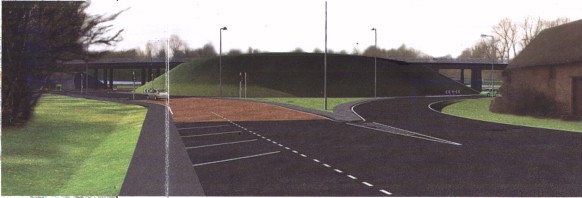
2. Countess Roundabout grade separated junction from the north (the
view shown is on opening day before planting on the central island is established).
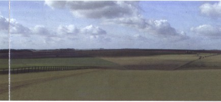
3. Looking towards Stonehenge from King Barrow Ridge after removal
of traffic (the proposed byway replacing the existing A303 would run parallel
to the fenceline).
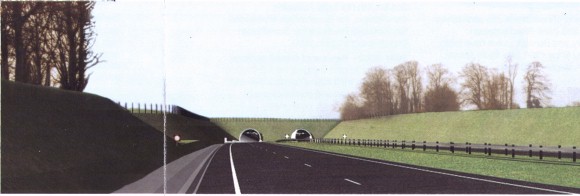
4. Eastern Tunnel Portal (King Barrow Ridge and Stonehenge Cottages
are in the vicinity of the existing clump of trees on skyline).
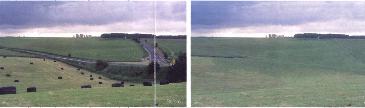
5. Stonehenge from the south looking across Stonehenge Bottom - before
(left) and after (right).
Further information
The full Environmental Statement may be inspected free of charge at the following locations from 5th June 2003 until 4th September 2003:- Information Point
- Information Point
- Wiltshire County Council
- Salisbury District Council
- Amesbury Town Council
- Government Office for the South West
- Salisbury Library
- Amesbury Library
Highways Agency
Ground Floor
Romney House
43 Marsham Street
London
SWlP 3HW
Highways Agency
Room 2/27a-H
Temple Quay House
2 The Square
Temple Quay
Bristol BS1 6HA
Bythesea Road
Trowbridge
Wilts BA14 8JN
The Council House
Bourne Hill
Salisbury
Wilts SP1 3UZ
c/o Amesbury Tourist Information Centre
Redworth House
Flower Lane
Amesbury
Wilts SP4 7HG
Bristol Office
2 Rivergate
Temple Quay
Brstol BS1 6ED
Market Pace
Salisbury
Wilts SP1 1BL
Smith Field Street
Amesbury
Wilts SP4 7AL
The Stonehenge Project
Highways Agency
Zone 2/05 - K
Temple Quay House
2 The Square
Temple Quay
BRISTOL BS1 6HA
[For information about the costs, see the printed version of this leaflet.]
Alternatively a CD of the full Environmental Statement Volumes 1 and 2 may be ordered at a cost of £20.
Your views
If you wish to Support, comment on or object to the draft Orders; put forward alternative proposals; or comment on the Environmental Statement, you should write not later than 4th September 2003 to the Highways Agency at the Stonehenge Team address shown opposite.What Happens Next
Depending on the nature and number of objections received, a Public Inquiry may be held before an independent Inspector. If a Public Inquiry is to be held, all those who have responded will be notified individually at least six weeks beforehand and notices will appear in the local press. All comments received will be made available to the Inspector who may decide to make them public. Publicity will be given to any alternative proposal received. The Secretary of State for Transport will consider the Inspector's recommendations (in the event of a Public Inquiry) and decide on the way forward.Public Exhibition
A public exhibition of the proposals will be held at:The Antrobus Arms Hotel Amesbury
Thursday and Friday, 12th and 13th June 2003 opening hours 10am to 8pm
Saturday 14th June 2003 opening hours 10am to 5pm
Detailed plans arid general details of the proposals together with proposed measures to reduce the environmental impact will be on display.
Representatives of the Highways Agency and their consultants will be available at the exhibition to explain the proposals.
Highways Agency an Executive Agency of the Department for Transport.